
May 2011
John Vincent Bellezza
Flight of the Khyung sets off through the 13 layers of the heavens to uppermost Tibet once again, bringing you more of its ancient signposts. This month’s issue looks at seven mountaintop strongholds documented on the Changthang Circuit Expedition (1999) and the Upper Tibet Circumnavigation Expedition (2000). In this newsletter you will see some of the first published color images of the ruined fortresses. These archaeological sites were first featured in Antiquities of Northern Tibet, Antiquities of Upper Tibet and other publications of mine.
For those of you who remain curious about the spirit-mediums or shamans of Upper Tibet, please see my new online article, “The Liturgies and Oracular Utterances of the Spirit-mediums of Upper Tibet in An Introduction to their bSang Rituals” in Revue d’Etudes Tibétaines, no. 20, pp. 5–31.
Six archaic fortresses of Upper Tibet
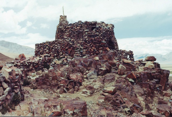
Fig. 1. The Yellow Fortress (rDzong-Ser) at 4720 m above sea level.
The fortress is situated not far from the large lake of Kyareng Tsho (Skya-reng mtsho). The main structure of the summit complex consists of an all-stone corbelled building with an irregular ground-plan. It exemplifies the salient architectural features of all-stone archaic constructions including corbelled roofs, rounded walls, small windowless rooms, buttressed walls, and diminutive entranceways. This particular structure is known as Happiness Retreat (Skyid-phug) and is 10 m in length. Like most other all-stone corbelled edifices of Upper Tibet, Happiness Retreat dates to either the protohistoric (100 BCE to 650 CE) or early historic period (650 to 1000 CE). It was given over to Buddhist religious practice until the Communist period. Happiness Retreat is remarkably intact despite the building having been seriously damaged in the Chinese Cultural Revolution. It is one of the best candidates in all of Upper Tibet for refurbishment, an undertaking that could have significant cultural and economic benefits for the region. Happiness Retreat consists of just four tiny rooms, the innermost of which still functions as a shrine. Happiness Retreat and the stone pathway that surrounds it are just one element in what was once the large facility of Yellow Fortress. The remainder of this stronghold fell to ruin and was converted into a Buddhist pilgrimage site an unknown number of centuries ago. For more information about the Yellow Fortress, see Antiquities of Zhang Zhung, vol. 2: www.thlib.org/bellezza
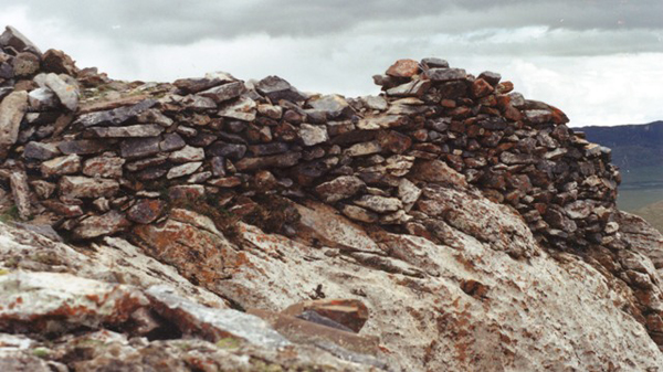
Fig. 2. Kyeri Trowo Tobgyal Khar (Skyes-ri khro-bo stobs-rgyal mkhar, Growth Mountain Citadel of King Wrathful Powerful)
This tiny summit fasthold is one of a handful of archaic fortresses in the eastern Changthang. Situated at nearly 5000 m, it is said to have been built by Trowo Tobgyal, a minister of Dud Lutsen (bDud klu-btsan), the region’s ruler and one of the primary villains in the King Gesar epic. The fortress consists of just a single sandstone and limestone structure (7.5 m x 4 m), which has been leveled to its revetment and lower walls. That Kyeri Trowo Tobgyal Khar is an archaic monument is indicated by its epic association with the non-Buddhist ruler of the region, the lack of a contemporary permanent water source in the vicinity, the extremely high and isolated aspect of the site, and typological parallels with the so-called Mon castles of the western Changthang.
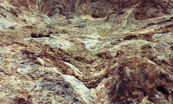
Fig. 3. Rock Face (Brag-gdong) at approximately 4400 m above sea level
This early citadel is named for a craggy limestone mountain in northwestern Tibet. The vestiges of ramparts and small buildings are found all over this rock formation. The installation enjoyed a strategic position above an important agricultural basin, one of the few that is still being farmed in northwestern Tibet today. According to the local oral tradition, Rock Face was founded by the Mon, that ancient tribe that is supposed to have colonized Upper Tibet before the arrival of the Buddhist Tibetans. In this image you can see the central amphitheatre, a key defensive installation of the site. It consists of a series of ramparts arrayed at different elevations, a defensive trait replicated at many archaic strongholds in Upper Tibet.
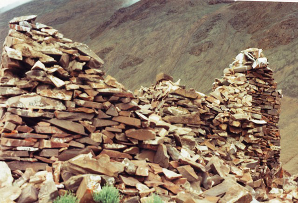
Fig. 4. Lightening Shelter Castle (Glog-phug mKhar)
This ancient citadel is also situated in northwestern Tibet at around 4600 m. In the vicinity is much rock art, some of which must have been carved when this stronghold was still active. The redoubt is comprised of a number of residential complexes interconnected through curtainwalls. Like Rock Face, it overlooks a lake, the basin of which constitutes an important local grazing land. At the site a network of ramparts runs along the ridge-tops for some 600 m. These walls must have permitted the home military force to move at will along the flanks of the mountain. The buildings of Lightening Shelter Castle were constructed with sandstone slabs, using the Upper Tibetan corbelling technique. In the image published here, there is a close-up of the largest single building of Lightening Shelter Castle (13 m x 13 m). Its crumbling walls still reach 2.5 m in height. Only one corbel still remains in situ in this structure, and there are no signs of mortar remaining in the wall seams.
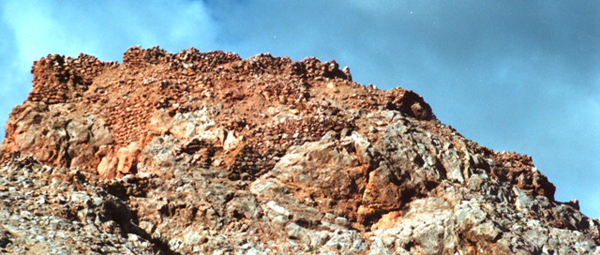
Fig. 5. Ruins of Brave and Strong Hero Pasture (Dpa’-ngar gzhung khang-gog)
This sprawling stronghold is situated near the banks of the upper Indus River at around 4600 m. It appears that this site was redeveloped at least one time, thus its structures date to different periods, including those built after the early historic period. Located above a major confluence, Ruins of Brave and Strong Hero Pasture occupies a strategically vital location. The pastures here are still of utmost importance to the pastoral economy of this corner of the western Changthang. Pictured here is the east complex, a compact mass of ruined buildings that sits on the top and on the north side of the formation, which rises some 80 m above the surrounding pasture. The wall segments here are up to 4 m in height. The random-rubble walls of the various structures were cemented using a reddish mud mortar, which has leached out and stained the limestone blocks red. The larger west complex of Ruins of Brave and Strong Hero Pasture measures 75 m x 19 m.
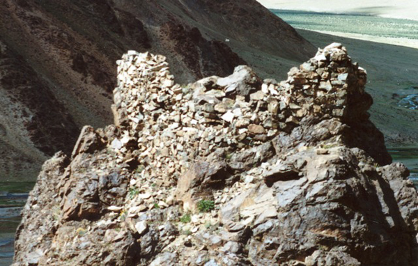
Fig. 6. Ruined Walls of Kabren (Skabs-ren gyang-gog)
This small fortress is located in a remote valley of northwestern Tibet which is now fully pastoral in character. In addition to the summit installation pictured here, there was a larger residential complex at the foot of the formation. It is said that at that time of its occupation, agriculture was practiced in the Kabren valley. The summit complex rises 140 m above the valley and is dominated by just one small building (9 m x 3 m). Situated at 4700 m elevation, the ruins stand as much as 2.2 m in height and were built at two different levels. Three rounds of tamarisk were integrated into the stonework of the lintel. One of these rounds of wood was subjected to Radiometric analysis and yielded a date of circa 1250 CE. This demonstrates that Ruined Walls of Kabren was active well after the early historic period. However, its foundation date has not been determined. It is certainly possible that it is an older facility that underwent refurbishment circa 1250 CE. The attribution of the site to the ancient Mon tribe in local folklore may suggest such a scenario. For the dating of Ruined Walls of Kabren and other strongholds in Upper Tibet attributed to the Mon, see my book Zhang Zhung.
Zhang Zhung’s fabled capital?
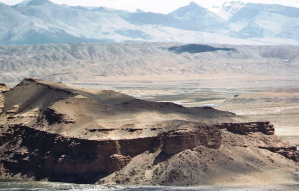
Fig. 7. The mesa on which the stronghold of Castle Face was built. The ruins are found all over the summit of this formation. In the background is the Sutlej river valley and mountains east of Castle Face
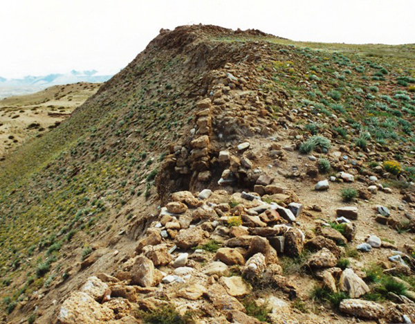
Fig. 8. A section of the defensive wall that lined the rim of the mesa at Castle Face
This wall is 65 to 80 cm thick and 2 m to 3 m in height along its outer side. Ruins of other defensive walls are found on the steep flanks of the hillside below the summit. Also below the summit, on the south flank of the hill, are the highly eroded earthen walls of a small reservoir.
Fortress Face (Mkhar-gdong) is located in southwestern Tibet, in the upper Sutlej valley. This site was equated with the fabled Horned Eagle Valley Silver Castle (Khyung-lung dngul-mkhar) by the famous Bon lama Khyungtrul Jikme Namkha Dorje (Khyung-sprul ’jigs-med nam-mkha’ rdo-rje), some 70 years ago. Of course, in Tibetan literature, Horned Eagle Valley Silver Castle is recorded as the main capital of the Zhang Zhung kingdom. The highly degraded ruins of Fortress Face cover approximately 20,000 m², making it one of the largest ancient strongholds in Upper Tibet. In addition to the parapet wall that once lined much of the rim of the mesa, the summit is blanketed in piles of rubble and depressions. There are also small standing wall segments on the summit, but not enough remains intact to gauge ground-plans. Nonetheless, from the amount of debris dispersed on the site it would appear that significant structures once stood here.
According to three elderly disciples of Khyungtrul Jikme Namkha Dorje I have had the opportunity to interview, this lama pronounced Castle Face the Horned Eagle Valley Silver Castle after discovering what he believed was a statue of the 8th century CE Bon saint Drenpa Namkha (Dran-pa Nam-mkha’) at the site. Bon sources tells us that Drenpa Namkha’s father, Gyungyar Mukö (rGyung-yar mu-Khod), was the king of Zhang Zhung; his capital none other than Horned Eagle Valley Silver Castle.
This identification of Fortress Face with horned Eagle Valley Silver Castle, however, escaped Giuseppe Tucci during his 1935 to the region. Instead, Tucci held that Eagle Valley Silver Castle should be identified with caves and ruins found 15 km downstream of Fortress Face in the village of Khyunglung. Following his lead, a number of Tibetologists (most of whom have never visited western Tibet) have made the same claim regarding the site in Khyunglung village. Nevertheless, in my survey of this village, I show that the ruins associated with the main cave complex date to no earlier than the second diffusion of Buddhism (see Antiquities of Zhang Zhung, vol. 1). As I also point out, there are indeed two archaic strongholds in Khyunglung, but neither is large enough or strategically important enough to have been the capital of Zhang Zhung.
Recently, two well known Tibetologists working separately on flimsy textual evidence have disputed the location of the capital settled upon by Khyungtrul Jikme Namkha Dorje. It is understandable that the capital of Zhang Zhung and its exact location are of great interest to Tibetologists. Horned Eagle Valley Silver Castle is first mentioned in the Old Tibetan Chronicle and other Old Tibetan sources, indicating that its existence was indeed a historical fact. In the scriptures of Bon, this castle has been transformed into a splendorous palace. According to the 13th century CE text Kun bum, on its golden foundations rise walls of silver and its roof grazes the highest of the 13 levels of the heavens. It is said that the chief god of Zhang Zhung, Gekhö (Ge-khod) resided in Horned Eagle Valley Silver Castle and for his pleasure, the sacred musical instruments of ancient Tibet, the drum, flat-bell and conch, were played.
By tallying the accounts in various Bon texts, we learn that in Horned Eagle Valley there were supposedly three different forts: Khyunglung Ngulkhar, Shele Dzongphuk (She-le rdzong-phug) and Zowo Khyungtse (Zo-bo khyung-rtse), as well as two cities: Gyalwa Nyepa (Rgyal-ba mNyes-pa) and Deden Ötro (Bde-ldan ’od-’phro). Judging from these sources, it appears that Horned Eagle Valley was a nexus of permanent settlement in the time of Zhang Zhung. This accords well with the existence of three archaic fortresses and various troglodytic settlements I have surveyed in the immediate region and many more within 50 km of Fortress Face. In the proximity of Castle Face are a number of burial sites, the largest of which I documented in 2002. This necropolis is in fact the biggest found to date in Upper Tibet and contains stela, funerary mounds and enclosures. One burial in the vicinity of Castle Face has been dated through radiometric analysis to circa 3rd century CE. The diverse objects recovered from this tomb reflect the existence of a sophisticated culture, one that enjoyed trade relations with Han China and the Indian Subcontinent in the time of the Kushana (see October 2010 newsletter for more details).
While we cannot yet prove that Castle Face is Horned Eagle Valley Silver Castle, the archaeological evidence assembled thus far supports this identification. First of all, in terms of size and placement, Horned Eagle Valley Silver Castle is the most dominant site in Horned Eagle Valley. Furthermore, the formation on which Castle Face stands is a crucial geomantic hub formed by the confluence of three rivers. The site also straddles trade routes connecting southwest and northwest Tibet, the Indian Himalaya and western Nepal. Archaeological work carried out at Castle Face by a Sino-Tibetan team led by Hou Wei and Mark Aldenderfer, in 2003, has found evidence for activity at the site between circa 400 and 700 CE, a timeframe that coincides with the existence of the Zhang Zhung kingdom. It also appears that there may have been two earlier periods of human activity at Fortress Face, dated 1500 to 500 BCE and 100 BCE to 500 CE. This Sino-American team charted over 80 structures on top of the Castle Face mesa. It also recovered many stone mortars, pestle and basins from the site, as well as shards of unglazed redware. Clearly, this was once a consequential residential center. A copper alloy spearhead, copper alloy arrowheads, iron lamina from a set of armor, and a small copper alloy statue were also discovered at Fortress Face.
Hopefully in the next few years more archaeological research can be conducted at Castle Face, with an eye towards confirming its true identity. The identification of Horned Eagle Valley Silver Castle, the capital of Zhang Zhung, hangs in the balance.