
August 2011
John Vincent Bellezza
Fifth anniversary issue of Flight of the Khyung
Welcome to fifth anniversary of this newsletter (2006–2011)! For the last five years it has offered readers like you highlights of the archaeology and cultural history of pre-Buddhist Upper Tibet, as well as a host of other subjects. If you have any suggestions for topics you would like to see covered in subsequent issues please do write me.
Antiquities of Zhang Zhung is published
After three years of technical development, I am very pleased to announce the publication of Antiquities of Zhang Zhung. This two-volume online publication from the Tibetan & Himalayan Library (based at the University of Virginia) is available free of charge at: thlib.org/bellezza. Featuring over 400 archaic archaeological sites surveyed in Upper Tibet between 2001 and 2008, this gazetteer provides systematic descriptions of each site, photographs, static maps, and glossaries, etc. This is a state-of-the-art website with many great features such as interactive maps, the ability to view Tibetan names in phonetics or in transliteration, image search functions, and print-out formats. Publishing such a large work (more than 400,000 words) online is an experiment. Do let me know what you think about it. Is the internet really the wave of the future for scholarship? I, for one, hope that in addition to the worldwide web, books will continue to be published, not least of all because they may prove more long lasting.
The estates of the ancients: Residential sites surveyed around Lake Dangra
In this 61st Flight of the Khyung we shall take a look at archaic residential structures discovered around Dangra Yumtsho on the Changthang Circuit Expedition (CCE), in 1999. These habitations appear to have primarily housed the ancient religious elite of the region, the priests known as bonpo and shen. Historical and typological indications suggest that the majority of these sites were established prior to the 7th century CE, but some may have been actively used in the early historic period (650–1000 CE). Small bands of ascetics may also have exploited them at a later date; nevertheless, the zenith of settlement in the region occurred in the prehistoric epoch.
The buildings shown below belong to the archaic culture heritage of Upper Tibet, a small piece of its vast monumental holdings. The color images in this newsletter were published in black & white in Antiquities of Northern Tibet (as well as one photo from Antiquities of Upper Tibet). I think you will agree that they look much better in color. With 12 more years of exploration and research under my belt, the descriptions that follow speak of what I have learnt is most significant.
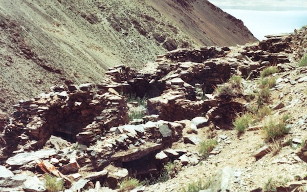
Fig. 1. The lower complex (21 m x 7 m) of one of the archaic temple complexes found along the shores of Lake Dangra. At this site there is a similarly built upper complex as well. In the upper right hand corner of the photograph, the sacred lake of the goddess Dangra Lekyi Wangmo is visible
This temple (sekhar) ruin is situated 400 m above Dangra Yumtsho, higher than any contemporary settlement on the lakeshore. According to the oral tradition collected from highly respected elders of the region (most of which have since passed away), this structure was a Zhang Zhung religious center. The location of the site well away from the agrarian communities of the lake and the elaborate all-stone corbelled construction of the edifice does seem to corroborate this identification. This multi-roomed structure was built at least 2 m into the rear slope, giving it a semi-subterranean aspect. Stone roof appurtenances still teeter on the walls of the more than one dozen rooms of the structure. The small size of these rooms (the largest measures 4 m x 2.5 m) demonstrates that, like many of its temple counterparts, this building did not host large gatherings within its walls. Therefore, we might surmise that it was given over to more contemplative religious practices. This building potentially sheltered many people, thus function as a domestic space for family use may also be indicated. According to the texts of the Bon religion, many early masters were laypeople with wives and families. The proliferation of small rooms seems amenable to such scenario. If so, esoteric religious observances and the mundane demands of family life may have existed side by side.
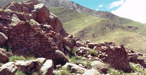
Fig. 2. This group of ruined all-stone corbelled buildings is one of several complexes belonging to another archaic residential installation at Lake Dangra
This complex extends for 19 m and was split in three levels. In its time this aggregation of edifices must have had an impressive profile. Like most other archaic sites around Dangra Yumtsho, this example is attributed in the oral tradition to Zhang Zhung, a kingdom that has attained mythic status in Bon. The term Zhang Zhung has come to embrace the ethnic, linguistic, cultural, and political dimensions of ancient civilization in Upper Tibet. However the pre-Buddhist residents of the region referred to themselves, thousands of well-built buildings, such as the ones pictured above, indicate that the Upper Tibetans had indeed attained a formidable level of technological and cultural advancement. In the vicinity of this site are defunct agricultural fields, vestiges of a sedentary culture that was once far more developed than in recent centuries.
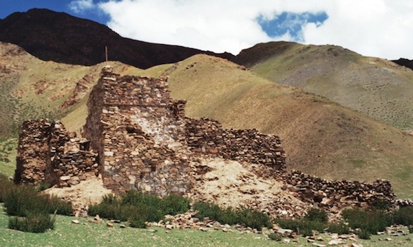
Fig. 3. A rebuilt all-stone corbelled two-story temple
According to the monks of Dangchung monastery this structure was originally a Zhang Zhung era temple, which was rebuilt by one of four Nyingma lamas known by the epithet Trowo (Khro-bo). These lamas lived between the early 15th century and the late 17th century CE. This Buddhist retreat center was almost leveled in the Chinese Cultural Revolution, but was rebuilt in a more rudimentary manner by the 17th titular head of Dangchung monastery (died in 1998). Earlier, circa the 11th century CE, a Bon text records that a Dzokchen master named Yungdrung Rinchen mediated at this location. He may have sheltered in one of the caves found in the escarpment below the site. These caves were once part of an extensive troglodytic settlement, as evidenced in a series of masonry façades and other lithic appointments. This cave town is traced back to Zhang Zhung by local residents and may have formed the original locus of settlement at Dangchung. Sometime after Yungdrung Rinchen’s tenure the entire locale devolved to the Buddhists.
Structural extensions are found on both the north and east sides of the current building, probably indicating that the original structure was significantly larger. The Buddhist hermitage consists of three small rooms laid out in a U-shaped pattern, which are set atop the old foundations. These rooms function as a sleeping space, kitchen and living quarters. The design of these modern additions was strongly influenced by the old building plan, as revealed in the small size and alignment of the rooms and the rounded walls. It is in the basement that the ancient architectural credentials of the building can be seen. It is comprised of two small, fire-blackened, semi-subterranean chambers oriented in the cardinal directions. The partition dividing the two chambers is a load-bearing wall for the all-stone corbelled superstructure above it. On a rock outcrop looming over the Buddhist retreat are the remains of an archaic fortification.
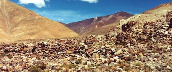
Fig. 4. A partial view of a village at Lake Dangra thought to have been abandoned centuries ago
It is believed that this once populous settlement collapsed due to a lack of water. Covering some 1800 m in a dense agglomeration of houses, perhaps two hundred or more people once lived here. The houses of this erstwhile population center were built in various ways, suggesting that it may have developed in various stages over a substantial period of time. According to the oral tradition of the region, this village was founded in ancient times and became deserted hundreds of years ago due to a lack of water. The watercourse that lies below the site is now often dry even in the summer rainy season. At one time an irrigation systems built around it must have watered the extensive fields of the defunct village. Dwindling water supplies threaten all the remaining agricultural villages of Lake Dangra. In this highly marginal physical environment the problem is particularly acute but wider parallels can be drawn to many other regions of Tibet and beyond.
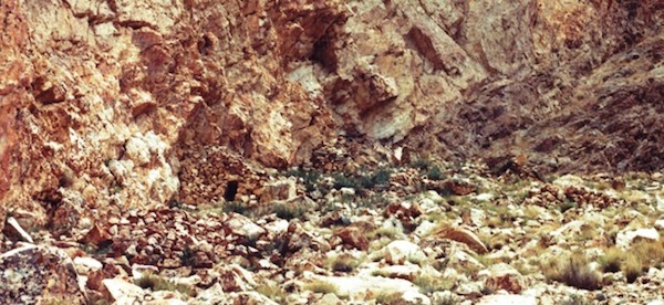
Fig. 5. A view of a few ruined structures at what was once an extensive residential hub at Lake Dangra
According to what senior residents of the region told me back in the 1990s, this was a Zhang Zhung religious precinct of great importance. A portion of the uppermost of three sites is shown here. This site is clustered around a bright orange limestone escarpment and consists of over two dozen free-standing structures as well as a number cave shelters. At least some of these domiciles had all-stone corbelled roofs and most caves were modified with façades and antechambers.
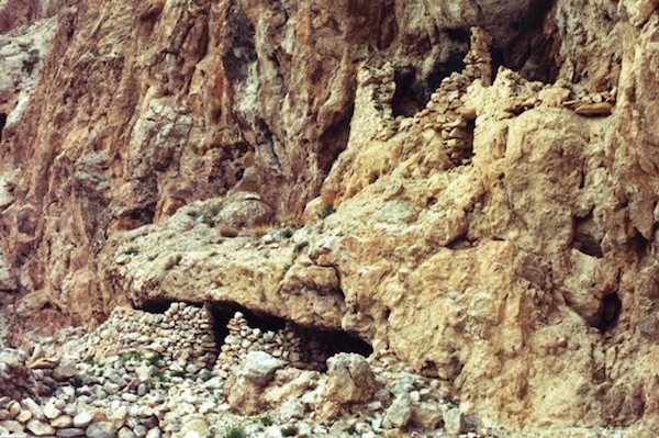
Fig. 6. Two ruined structures at another ancient cave temple of the Lake Dangra region
This site is located in what is now a Buddhist area and much of its old history has disappeared. The Bonpo are more inclined to retain or recreate tales of the prehistoric past than are Buddhist residents. For the Bonpo the distant past amounts to halcyon days. There is some validity in this belief, in that the extent of sedentary occupation in Upper Tibet was far greater in the Iron Age and protohistoric period than in pre-modern times. Most of the monumental architecture of the Changthang dates to a time before Buddhism came to dominate the religious complexion of this vast region.
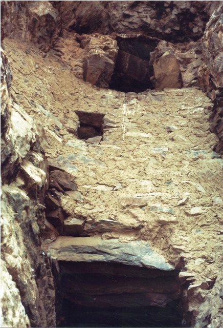
Fig. 7. A portion of a three-story façade built around a cave at another troglodytic settlement of Lake Dangra
In the oral tradition, this large site with its dozens of buildings and caves is associated with an incursion or colonization of the region by Central Asians. Referred to in the region generically as Sokpo, this does not necessarily denote the Sogdians with which the imperial period Tibetans had dealings. In the vernacular, this term may also refer to other ancient Inner Asian peoples.
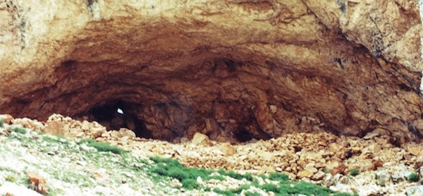
Fig. 8. The giant cave and associated manmade structures known as White Fortress (Rdzong dkar-po)
The massive ruined façade that once enclosed the cave is 24 m in length and the cave itself is more than 10 m deep. This hidden and hard to access site is said to have been where the Zhang Zhung master Takla Member (Stag-lha me-’bar) meditated. Whether this is a historical fact or not, the sheer size of the cave and residential structures associated with it, indicate that White Fortress was once much more than the haunts of a single ascetic.
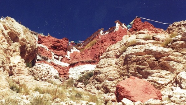
Fig. 9. A modern day cave temple at Mamik monastery in the western Changthang
This Nyingma monastery follows in the footsteps of the great cave temples of Zhang Zhung. Even with the Buddhacization of Upper Tibet, her religious leaders were still attracted to caves for the foundation of their monasteries. These caves were imbued with a sacred aura and provided secure shelter in a region with one of the fiercest climates in the world. A number of Upper Tibetan Buddhist monasteries were established on the site of archaic religious installations. However, the vast majority of early residential sites were never reoccupied. Some of these locations were simply too high and remote for historic era settlement. These forsaken places are now only pieces in an archaeological puzzle that I have spent a working lifetime trying to put back together.
The Changthang Circuit Expedition: A retrospective from my journals
July 20, 1999
The 40th day of the Changthang Circuit Expedition. Finally after 13 years, I learned the name of the lake (Sgyu-ma’i mtsho) I traversed in 1986. Thus far on the expedition I have completed about 3500 km of travel and have written 170 pages of journal entries. We remained in Yakra until midday – I had to catch up on my writing and pursue questions I still had. When we did leave, we headed northeast and then along the Wamo (Fox) valley. Our destination was Ngangla Ringtsho but we only got as far as the settlement of Khangpa Kargok, which is in Marmik, Gerste county. Traditionally, this area was part of the Trokpa region of Sekhor. We made camp in a meadow along the waterfront. The only residents in the settlement appear to be a 65-year old ngakpa and his grandson. The rest of the community is in summer pastures to the north. With few sources to draw from there is little research to do. The Wamo valley has extensive swampy pastures and I wonder why it is not more densely populated. I tried to get information on nearby Ngangla Ringtsho from some passing yak herders but learned little. Yes, there is a large island called Tsho Do which is accessible in the winter and which is supposed to have some ancient ruins. We were informed that on the north side of the Wamo valley, at a place called Nyima Dong, there are stone pillars, but a 22 km roundtrip excursion only turned up naturally occurring boulders and one upright stone of indeterminate [archaeological] age. West of Khangpa Kargok, along the route we came in on, there are supposed to be a few ancient ruins near Lhamo Dungkhyer (Spear Carrying Goddess), a black mountain extending deep into the Wamo valley. This evening the ngakpa took me into his little chapel. He managed to save some old religious articles by burying them for a period of 16 years. The pace of activity slowed considerably this afternoon, not a bad contrast from populous Yakra. We discussed continuing to Marmik but it has been decided that we will return to Shungpa. I hope to make a few stops en route. There is still so much to see and explore on this expedition!
October 8, 1999
We got underway this morning none too early but this trend suits me, especially when I have a lot of writing to do. Heading north along the improved road we reached the settlement of Sharsha. In the part of the settlement called Doring there is indeed a standing stone. This stele is 105 cm tall, 22 cm wide and 18 cm thick at the base. This inclined and heavily worn pillar was carefully shaped. It is located in plain view of the meridian range beside the two houses of Doring. It is said by a senior resident to be very old but he could offer no further information… From Sharsha we traversed a pass called Draksharra La, which provides a more direct route to Marmik Gonpa. We made the monastery in the late afternoon. This Nyingma institution is situated east of Marmik Tshamtsho in a rugged side valley. The head of the monastery is 72-year old Ngawang Loedro, the seventh in the monastery’s lineage. The lama has left to conduct prayer services but I found those left behind cooperative and interested in my work. I will describe the monastery tomorrow as we will be here for a day. The red outlier called Gob, an important territorial deity of Marmik, belongs to the tsen and, according to one of my best informants, Gob may be mounted on a brown bear (of which there are still a few in the meridian range). His mate is a white outlier in the meridian range west of Sharsha named Mapayu. They are said to have a child, a mountain east of Sharsha called Budum Dakri. I will now list the main mountains and valleys from Ka La to Mamik Tshakka…
November 2, 1999
Takrong (Stag-rong) is a Bonpo place of pilgrimage according to a number of people I have spoken to in the region. Apparently, it has never assumed a Buddhist identity or been appropriated by it. I think this must be one of the reasons that Lopon Tenzin Namdak [Bon’s seniormost scholar] and Menri Khenpo [the head of the Bon religion] place Takrong in such a prominent position. There are few sites in the old Zhang Zhung homeland that the Bonpo still control. According to a local man I spoke to, Takrong has a reputation of being hard hit with snow. Takrong (in ancient times called Walrong / Dbal-rong) is situated about 10 km upstream from where the Takrong Tsangpo debouches into a plain south of the Transhimalya range. The site is found on the left bank of the river. First the trail follows the river’s edge but during the second half of the walk it climbs above a gorge that forms around the watercourse. Just below the sacred hot springs there is a single drokpa zhima (gzhi-ma); the people here still permanently residing in a tent. Takrong is an area of extensive geothermal activity. Mineral aggregations have formed numerous pillars and outcrops, 18 of which are called Drekpa Chogye (Dregs-pa bco-brgyad) in Bon. According to my prime informant these are locally called Phonya Drepo Chogye (Pho-nya ’dre-po bco-brgyad), each with its own identity. This circle of spirits is ruled by the nedak (gnas-bdag) of Takrong…